Infrastructure
Positioning, Navigation, and Timing (PNT) Satellites
2017 – Positioning, Navigation, and Timing Systems – Snapshot
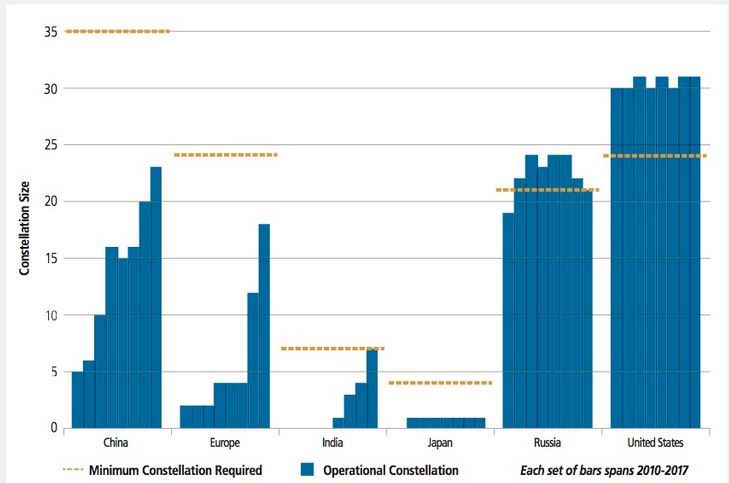
PNT satellite constellations continued growing during 2017. Deployments led to a 6% increase in the in-orbit PNT satellite population as a result of Chinese, European . . .
2016 – Positioning, Navigation, and Timing Systems – Snapshot
As the world’s population continued integrating space positioning, navigation, and timing (PNT) technologies and services, the number of PNT satellites continued to multiply in 2016, growing slightly more than ##% from 2015. Relative newcomers to PNT space operations, such as Europe, India, and China, grew their PNT constellations, each building an independent…
2016 – PNT Ground Networks – Snapshot
In 2016, the U.S. Air Force (USAF) continued to operate and maintain a large, combined-services ground network for its positioning, navigation, and timing (PNT) fleet, the Global Positioning System (GPS). Consisting of 15 monitoring stations and 11 command and control antennas, the network was commanded through the USAF’s
2016 – GPS – Snapshot
While the U.S. Air Force (USAF) maintained ## operational satellites in its Global Positioning System (GPS) positioning, navigation and timing (PNT) fleet, the U.S. share of overall global operational PNT satellites ## from ##% in 2015 to ##% in 2016. This was due to other nations, such as…
2016 – GLONASS- Snapshot
Although Russia increased the overall number of its Global Navigation Satellite System (GLONASS) positioning, navigation, and timing (PNT) satellites, the number of operational GLONASS satellites decreased by ## during 2016. The country’s share of the world’s operational PNT satellites shrank to ##% in 2016, falling behind…
2016 – QZSS – Snapshot
In 2010, the Japan Aerospace Exploration Agency (JAXA) launched a single positioning, navigation, and timing (PNT) satellite as a start for its Quasi-Zenith Satellite System (QZSS). Japan has not launched other satellites into the QZSS constellation since. Japan’s 2016 share of the world’s operational PNT satellites was ##%. The country plans to…
2016 – NavIC – Snapshot
During 2016, India completed the first phase of a two-phase plan for its positioning, navigation, and timing (PNT) satellite system, the Indian Regional Navigation Satellite System (IRNSS). Upon the launch of the final IRNSS satellite, the Indian government renamed IRNSS the Navigation with Indian Constellation (NavIC). The country launched…
2016 – Galileo – Snapshot
Europe continued launching Galileo satellites during 2016, enlarging its positioning, navigation, and timing (PNT) constellation. Thanks to the launch of ## more Galileo satellites, the Europeans managed to grow their share of the total global operational PNT satellites by about ## percentage points for 2016 to ##%. Europe’s…
2016 – BeiDou – Snapshot
China’s expansion of its positioning, navigation, and timing (PNT) constellation, BeiDou, continued during 2016. The country’s share of the world’s orbiting operational PNT satellites increased to ##%, ## more than its share in 2015. China’s share of PNT satellites exceeded…
2015 – PNT Ground Networks – Snapshot
The current U.S. Global Positioning System (GPS) ground control segment consists of a variety of ground antennas, monitor stations, and Air Force Satellite Control Network (AFSCN) Remote Tracking Stations. The 16 monitoring stations, including those owned by the National Geospatial-Intelligence Agency, and 12 command and control antennas, are all operated by the master control station in Colorado, or the alternate master control station in California.