United Kingdom
2013 – Demographics
Science and engineering courses offered at the secondary school level are important for preparing students to pursue STEM degrees. Not only may students with more exposure be more likely to pursue a STEM degree upon reaching university, but research suggests that they are more likely to actually complete that degree.
2013 – TIMSS

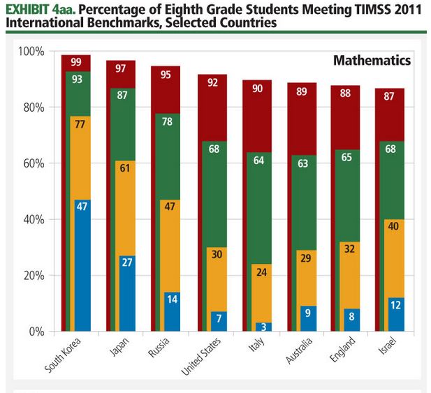
The TIMSS study also assesses mathematics and science knowledge and skills. Unlike PISA, which focuses on broader mathematical and scientific literacy of students nearing the end of compulsory education, TIMSS is designed to align broadly with the mathematics and science curricula in participating countries at the fourth and eighth grade (approximately 9- and 13-year-old) levels.
2013 – PISA
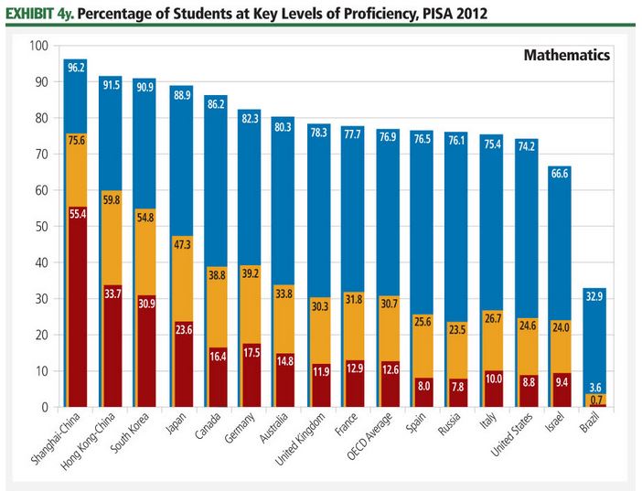
Trends in international primary and secondary STEM education can be compared across countries using two widely respected international exams. The Programme for International Student Assessment (PISA), carried out by the Organisation for Economic Co-operation and Development (OECD) every three years, focuses on the capabilities of 15-year-old students in mathematics and science literacy.
2013 – European Space Industry Employment
Space employment in Europe has increased for the seventh year in a row, adding about ## employees from 2011 to 2012, an increase of ##%. European space employment is ##% greater than its 10-year low in 2005. Unlike the data for the U.S. space workforce, which is estimated using nationally collected data not specifically designed to capture the space industry, data on the European space workforce has been collected via a targeted survey of European space companies carried out by a not-for-profit organization, Eurospace. In carrying out this survey, Eurospace focuses on manufacturing activities and measuring end-market value.
2013 – Fixed Satellite Service (FSS) Satellite Design Activities
Over the past few years, several companies have deployed new satellites designed to use the relatively less crowded Ka-band set of frequencies to support delivery of space-based internet broadband. Operators such as Eutelsat, Avanti Communications in the United Kingdom, and ViaSat in the United… Thank you for visiting The Space Report! The Authoritative Guide to…
Imaging and Tracking Ship Movement
Ships are required to transmit information regarding their location through the Automatic Identification System (AIS), but this data can be falsified and the requirement is not universally enforced. Supplementing AIS data with visual satellite imagery can help security and intelligence officials more accurately track ship movements.
2013 – An Evolving Space Industry: Commoditization, Differentiation, and the Rise of Regional Operators
The space industry is evolving, moving from a phase of testing and development in the mid-20th century, to limited satellite coverage and use by specialists in the late 20th century, to ubiquitous coverage and broad consumer adoption in the early 21st century. At the same time, traditional satellite… Thank you for visiting The Space Report!…
2013 – Land Imaging Snapshot
Collectively, land-imaging satellites—which are also known as Earth observation or remote sensing satellites—are systems used to observe, monitor, and track changes and developments on the Earth’s surface using a variety of optical or electronic imaging capabilities. Earth observation satellites may be distinguished from each other on the basis of spatial resolution—the level of detail their images are capable of recording. Another distinction is the sensor type, such as optical cameras, synthetic aperture radar (SAR), or various types of infrared and electronic imaging.