Malaysia
Per Nation Mass Share of an Estimated 973,000 KG, 2022
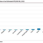
Operators deployed ~421 spacecraft with a mass of 200 kg or less, 18% of all deployed spacecraft in 2022. SpaceX’s Starlink satellites comprised over half the spacecraft mass deployed in 2022. The company’s Starlink deployments added up to 518,523 kg, nearly double the 257,140 kg it deployed in 2021. The largest spacecraft deployed during 2022 was Lockheed Martin’s Orion space capsule (25,848 kg), deployed during NASA’s first Artemis/Space Launch System launch.
Commercial Space Revenue Climbs More Than 6%, Edging Toward $400 Billion Annually
Commercial space activity refers to efforts undertaken by private industry with little or no government investment. Commercial space revenue in 2021 totaled $362 billion.
2020 TSRQ3 – Infrastructure: Human Spaceflight


Since Yuri Gagarin’s orbital flight around the Earth in April 1961, humans in pioneering new technologies and pushing the limits of what’s considered possible. This year ushered in a new era of human spaceflight when SpaceX became the first . . .
2014 – Satellite Communications
Satellite communications segment revenues for 2014 rose slightly to $## billion, ##% higher than the $## billion in revenue for 2013. Although broadcasts from satellites are a form of satellite communications, for the purposes of this report satellite communications are two-way transmission links between users and the satellites themselves. The links transmit data, voice, and video—although the distinction between…
Air Traffic Tracking and Traffic Control Space Solutions
Imagery and communications satellites were both used in search and rescue efforts for the Malaysian Airlines MH370 passenger airplane. Imagery of the search areas was provided on sites such as Tomnod in hopes that crowdsourcing imagery analysis would help in locating evidence of where the airplane might have disappeared.
Crowdsourcing the Search for a Missing Jet With Satellite Imagery
There are other ways to become even more involved with space activities. Satellite imagery companies are offering opportunities for people to provide imagery analysis. Crowdsourcing has become a key approach and has resulted in websites such as DigitalGlobe’s Tomnod.[
2014 – Additional Country Space Budgets
Around the globe, many smaller nations—whether in terms of economy or population size—are investing in space projects or programs. The exhibit below shows the most recent available annual budget for civil space activities in a number of selected space states.
2012 – Spaceports as an Economic Engine
The Falcon 9 launch vehicle carrying the Dragon C2 spacecraft lifts off from the SpaceX launch pad at Cape Canaveral Air Force Station. The Dragon was the first commercial spacecraft to successfully dock with the ISS and return to Earth, splashin… Thank you for visiting The Space Report! The Authoritative Guide to Global Space Activity,…
Satellite Pictures Help Fight Illegal Logging
The DeforestACTION project is using satellite imagery to combat illegal logging through its Earth Watchers software tool, currently in beta testing. The difficulty of locating and identifying illegal deforestation often prevents law enforcement from limiting this activity. DeforestACTION allocates each person involved in the project a piece of land to monitor, providing them with an updated satellite image each week so they can locate changes and disturbances.